


Traffic signsWorldwide
 Traffic rules
 Worldwide
101. Verge
A verge is the strip of land alongside a roadway, situated between the roadway and features such as a ditch, embankment, property boundary or other roadside area. A verge may be level with the roadway or raised above it and may consist of grass, gravel, soil or another surface.
A verge is normally separate from the roadway, pavement and cycle path. Depending on local traffic law, pedestrians, cyclists or vehicles may be permitted to use a verge in particular circumstances, and specific rules may apply to stopping and parking on it.
Wikimedia.org • Santeri Viinamäki • CC BY-SA
What is a verge?
A verge is an area alongside a roadway, generally between the roadway and a ditch, embankment, property boundary or other roadside feature.
Can pedestrians walk on a verge?
Yes, where local rules permit or require it. A verge may provide a walking route where no suitable pavement or dedicated pedestrian facility is available.
Should you drive onto a soft verge at high speed?
No. A soft or uneven verge can provide significantly less grip than the roadway and may affect steering or vehicle stability. Reduce speed and return to the roadway safely when possible.

102. Ring road
A ring road is a road or connected system of roads that runs around or partly around a city, town or urban area. It is designed to distribute traffic between different parts of the area and to allow through traffic to bypass congested central streets.
A ring road is not necessarily a motorway or expressway. It may consist of motorways, divided highways, ordinary roads or a combination of different road types. The applicable speed limits, access restrictions, priority rules and lane rules therefore depend on the individual section and the local traffic signs and regulations.
Wikimedia.org • Aktron • CC BY
What is a ring road?
A ring road is a road or connected route that runs around or partly around an urban area and helps distribute traffic between different destinations without requiring all traffic to pass through the centre.
🔗 gov.uk • Great Britain Highway Code, Rules 259 and 263–274; national guidance example
What is the speed limit on a ring road?
There is no universal ring-road speed limit. The applicable speed depends on the country, road classification, location and posted traffic signs.
🔗 gov.uk • Great Britain Highway Code, Rules 259 and 263–274; national guidance example
What should you do if you miss an exit on a ring road?
Continue safely to the next suitable junction or exit. Never reverse, make an unsafe U-turn or cross restricted areas in an attempt to return to a missed exit.
🔗 gov.uk • Great Britain Highway Code, Rules 259 and 263–274; national guidance example
103. Ramp
A ramp is a connecting road that allows vehicles to enter or leave another road, especially a motorway, expressway or other grade-separated road. Ramps are commonly used at interchanges to connect roads without requiring traffic to cross directly at the same level.
An entrance ramp leads traffic onto the main road, while an exit ramp leads traffic away from it. Drivers should follow the signs and road markings, adjust their speed and watch carefully for merging or diverging traffic.
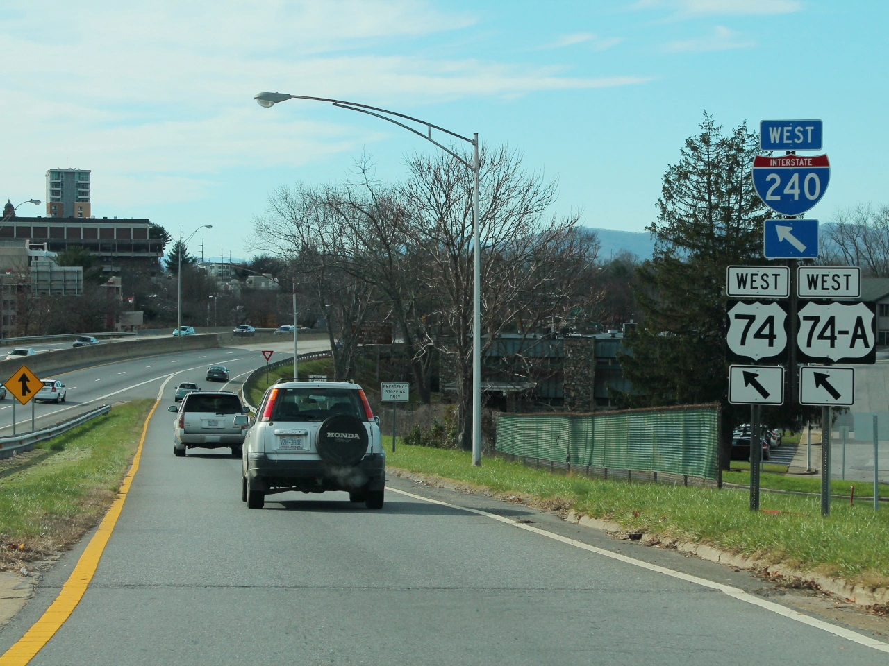
Wikimedia.org • formulanone • CC BY-SA
How should you use a motorway entrance ramp?
Follow the signs and road markings, use the ramp to adjust your speed to the traffic on the motorway and merge only when it is safe and permitted. The exact priority rules depend on the country.
🔗 gov.uk • Great Britain Highway Code, Rules 259 and 263–274; national guidance example
104. Exit
An exit is a designated route or point where traffic leaves a road, motorway, expressway or other major route. On high-speed roads, an exit usually leads from the main carriageway onto an exit lane or ramp that connects with another road or destination.
Drivers approaching an exit should follow the direction signs and road markings, move into the appropriate lane in good time and adjust their speed as necessary after leaving the main traffic flow.
Wikimedia.org • Marc Mongenet • CC BY-SA
What should you do if you miss your exit?
Continue safely along the road and use a later exit or another permitted route. Do not stop, reverse or make a dangerous sudden manoeuvre simply to reach an exit you have missed.
🔗 gov.uk • Great Britain Highway Code, Rules 259 and 263–274; national guidance example
105. Emergency lane
An emergency lane is a strip alongside the main traffic lanes of a motorway or other high-speed road that is normally kept free from regular traffic. It provides a place for vehicles that have broken down or are involved in an emergency and may also be used by emergency or authorised service vehicles where local rules permit.
Drivers should not use an emergency lane as a normal traffic lane. If a vehicle must stop there because of an emergency, occupants should follow the applicable safety procedures and remain as far away from moving traffic as possible.
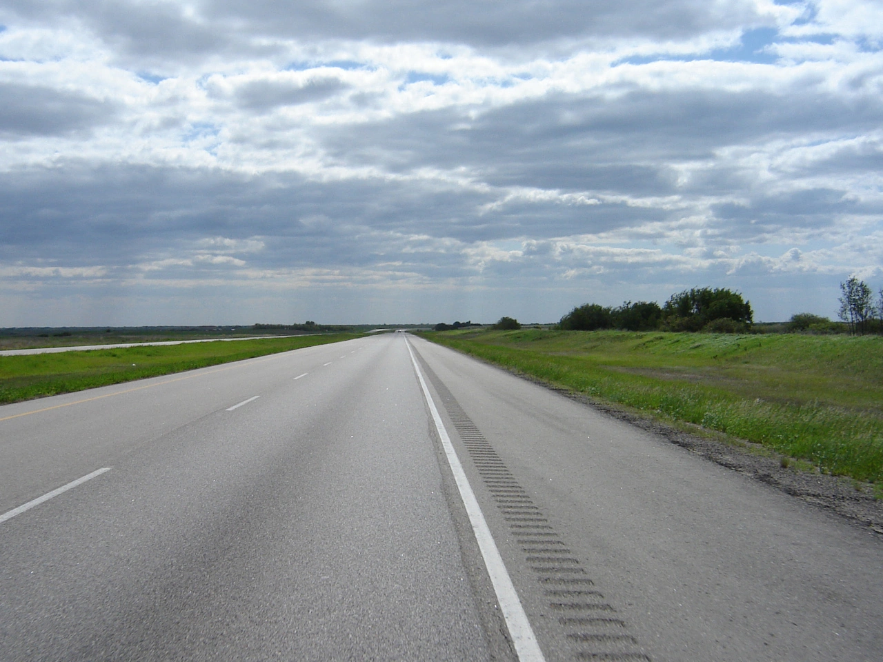
Wikimedia.org • SriMesh • CC BY-SA
What should you do if your vehicle breaks down in an emergency lane?
Stop as far from moving traffic as safely possible, switch on hazard warning lights and follow local breakdown procedures. Leave the vehicle only if you can reach a safer place away from traffic. If you cannot get out safely, remain belted and call emergency help.
🔗 gov.uk • Great Britain Highway Code, Rules 275–279; national guidance example
🔗 gov.uk • Great Britain Highway Code, Rules 270–274; national guidance example
106. Rush-hour lane
A rush-hour lane is an additional traffic lane that is opened temporarily when traffic is heavy to increase the capacity of a road. It is commonly found on motorways and may use part of the emergency shoulder or another lane that is normally closed to regular traffic.
Rush-hour lanes are usually controlled by dynamic signs or lane-control signals. Drivers may use the lane only when it is shown as open and must leave it when signs or signals indicate that it is closing or closed.

Wikimedia.org • Marco Raaphorst • CC BY
What should you do when a rush-hour lane is closed?
Do not continue driving in the lane when signs or signals indicate that it is closed. Move into an open traffic lane safely and follow any directional signals provided above the roadway.
🔗 gov.uk • Great Britain Highway Code, Rules 133–134; national guidance example
🔗 gov.uk • Great Britain Highway Code, Rules 257–258; national guidance example
🔗 gov.uk • UK Department for Transport, Know Your Traffic Signs, information signs
107. Traffic calming
Traffic calming refers to road-design measures intended to reduce vehicle speeds and improve safety, particularly in areas where vehicles interact closely with pedestrians and cyclists. These measures can include speed humps, raised crossings, narrowed road sections, chicanes, traffic islands and changes in road layout or surface.
The purpose of traffic calming is to encourage drivers to travel at a lower and more appropriate speed rather than relying only on speed-limit signs. The measures used and their legal requirements differ between countries.

Wikimedia.org • Rodhullandemu • CC BY-SA
Where is traffic calming commonly used?
Traffic calming is commonly used in residential areas, school areas, town centres and other places with significant pedestrian or cyclist activity.
🔗 hse.gov.uk • UK HSE, workplace transport speed and traffic-calming guidance
108. Information point
An information point is a designated place where travellers can obtain information about the surrounding area, local services, tourist attractions, routes or other useful facilities. It may be located beside a road, at a rest area, in a town or near an important destination.
Information points are often indicated by a service or information sign. Depending on the location, they may provide maps, brochures, route information, tourist assistance or digital information for visitors.
Wikimedia.org • Marc Mongenet • CC BY-SA
How is an information point indicated?
Many countries use a service or information sign to direct road users toward an information point. The exact symbol and sign design vary between countries.
🔗 rijksoverheid.nl • Dutch Government, reading motorway location markers; Dutch example
109. Horse riding
Horse riding includes activities involving horses and riders. In road traffic, an equestrian or horse rider may use roads, bridleways or specially designated routes, depending on the rules and infrastructure provided.
Drivers approaching horses and riders should reduce speed, leave sufficient space and avoid sudden noise or movements that could frighten the animal. Riders must also follow the traffic rules that apply to them.
Wikimedia.org • KiwiNeko14 • CC BY-SA
What does equestrian mean in road traffic?
Equestrian refers to horse riding and, in a traffic context, particularly to people travelling on horseback or using designated horse-riding routes.
🔗 gov.uk • Great Britain Highway Code, Rule 215; national guidance example
How should drivers behave near horse riders?
Drivers should slow down, leave plenty of space and pass calmly, avoiding sudden acceleration, horn use or other actions that could frighten the horse.
🔗 gov.uk • Great Britain Highway Code, Rule 215; national guidance example
110. Provisional licence
A provisional licence allows a learner driver to practise driving on public roads before obtaining a full driving licence. The conditions vary between countries and may determine whether the learner must be accompanied by an approved supervisor, which vehicles may be driven, where and when driving is permitted and how long the licence remains valid. A provisional licence is normally subject to stricter rules than a full licence and is intended specifically for learning and gaining practical driving experience.
Wikimedia.org • PKov7 • CC BY-SA
What is a provisional driving licence?
The meaning depends on the jurisdiction. In Great Britain and Flanders, a provisional licence can authorise learning under specified conditions. In the Australian Capital Territory, a provisional licence follows the learner stage and assessment. It is not a universal synonym for a learner licence.
🔗 vlaanderen.be • Flanders, obtaining a category B driving licence; learner provisional licences
🔗 gov.uk • GOV.UK, driving lessons and learning to drive; GB learner rules
Can you drive alone with a provisional licence?
Check the jurisdiction, licence stage and its conditions. In Flanders, some provisional licences require a registered supervisor, while another option permits independent practice after approved training. In Great Britain, car learners must follow the supervision rules. Other countries may use provisional for a later licensing stage.
🔗 vlaanderen.be • Flanders, obtaining a category B driving licence; learner provisional licences
🔗 gov.uk • GOV.UK, driving lessons and learning to drive; GB learner rules
How long is a provisional licence valid?
There is no universal validity period or renewal procedure. Check the issuing authority’s rules for the particular licence. For example, Flanders distinguishes 18-month and 36-month provisional learner licences; another jurisdiction may use provisional for a different stage altogether.
🔗 vlaanderen.be • Flanders, obtaining a category B driving licence; learner provisional licences
🔗 gov.uk • GOV.UK, driving lessons and learning to drive; GB learner rules
111. Hazardous cargo
Hazardous cargo, also called dangerous goods, consists of substances or articles that can create a significant risk to people, property or the environment during transport. Examples include explosives, flammable liquids and gases, toxic substances, corrosive materials and radioactive substances.
Transporting hazardous cargo can require special packaging, labels, vehicle markings, documentation, equipment and driver training. Additional route or tunnel restrictions may also apply depending on the type and quantity of dangerous goods being carried.
Wikimedia.org • Tabl-trai • CC BY-SA
Can hazardous cargo be prohibited on certain roads or in tunnels?
Yes. Routes and tunnels can restrict vehicles carrying dangerous goods. The signs, applicable dangerous-goods rules and the load determine whether a restriction applies. For example, Great Britain uses ADR tunnel categories A to E; these are not general speed categories for all vehicles.
🔗 gov.uk • UK Department for Transport, ADR tunnel categories; GB example
112. Emergency exit
An emergency exit is a marked escape route that allows road users to leave a tunnel or other enclosed traffic facility during a serious incident such as a fire, smoke development or another emergency. Emergency exits lead towards a safer area separated from the immediate danger.
In an emergency, occupants should leave their vehicle when evacuation is necessary and follow the emergency-exit signs and instructions. They should move away from the danger rather than remaining inside the tunnel or returning to their vehicle.
Wikimedia.org • Bennie91 • CC BY-SA
Should you take your vehicle through an emergency exit?
No. Tunnel emergency exits are intended for people evacuating on foot. Leave the vehicle when necessary and follow the marked escape route towards safety.
🔗 crisiscenter.be • Belgian National Crisis Centre, tunnel evacuation on foot
🔗 merseytravel.gov.uk • Merseytravel, road-tunnel evacuation instructions
🔗 gov.uk • UK DfT, emergency-exit pedestrian signs and information symbols
113. Runaway truck ramp
A runaway truck ramp, also called an emergency escape lane, is a specially constructed lane designed to stop a vehicle that has lost effective braking, particularly a heavy vehicle descending a steep hill. The ramp may use an uphill gradient, deep gravel or another energy-absorbing surface to slow and stop the vehicle.
A driver who has lost braking ability should enter the escape ramp as early and safely as possible rather than trying to continue down the hill. Escape ramps are emergency facilities and must not be used for ordinary stopping, parking or turning.
Wikimedia.org • Joshua Honeycutt • CC BY-SA
Can you use a runaway truck ramp for normal stopping or parking?
No. An escape ramp is an emergency safety facility and should be kept clear for vehicles that have lost effective braking or control.
114. Radio service
A radio service is a radio broadcast that provides drivers with traffic information such as congestion, road closures, accidents, weather conditions or other events affecting a journey. Roadside signs may indicate a particular radio station and frequency where traffic information is available.
Drivers can tune to the indicated frequency to receive local traffic information while travelling through the area. The service is informational and does not replace traffic signs, signals or instructions from authorised persons.
Wikimedia.org • Gestrandete • CC BY-SA
Do radio traffic reports override road signs?
No. Radio information can help drivers anticipate conditions and choose a route, but drivers must continue to obey traffic signs, signals, road rules and instructions from authorised persons.
115. Oversize load
An oversize load is a load that causes a vehicle or vehicle combination to exceed the normally permitted dimensions for road traffic, such as maximum length, width or height. Oversize loads often involve large machinery, construction components or other items that cannot reasonably be divided into smaller loads.
Transporting an oversize load may require a special permit, an approved route, warning signs, lights or escort vehicles. Drivers must comply with the conditions imposed by the authorities responsible for the roads on which the transport takes place.
Wikimedia.org • Cjp24 • CC BY-SA
Why might an oversize load need an escort vehicle?
An escort can warn other road users and help an unusually large vehicle negotiate its planned route. The required escorts depend on local rules and the transport’s dimensions and weight. Do not assume a private escort has police powers to stop or direct traffic; British guidance expressly distinguishes those roles.
🔗 assets.publishing.service.gov.uk • Highways England, abnormal-load self-escort guidance
116. Lane
A lane is a longitudinal part of a roadway intended to accommodate a line of moving vehicles. A roadway may contain one or several lanes for traffic travelling in the same or opposite directions.
Lanes are commonly separated by continuous or broken road markings. Traffic signs, lane arrows and lane-control signals may indicate which vehicles may use a lane, which direction traffic must follow or whether a lane is open or closed.
Wikimedia.org • KiwiNeko14 • CC BY-SA
What is a traffic lane?
A traffic lane is a longitudinal part of a roadway intended for a line of moving vehicles.
🔗 gov.uk • Great Britain Highway Code, Rules 133–134; national guidance example
🔗 gov.uk • Great Britain Highway Code, Rules 257–258; national guidance example
🔗 gov.uk • UK Department for Transport, Know Your Traffic Signs, information signs
Who has priority when changing lane?
A driver changing lane generally must give way to traffic already travelling in the lane being entered, although specific merging rules may apply in some situations.
🔗 gov.uk • Great Britain Highway Code, Rules 133–134; national guidance example
🔗 gov.uk • Great Britain Highway Code, Rules 257–258; national guidance example
🔗 gov.uk • UK Department for Transport, Know Your Traffic Signs, information signs
What should you do when your lane ends?
Follow the merging rules and road markings, observe surrounding traffic and move into the continuing lane safely. Special zipper-merging rules may apply during congestion.
🔗 gov.uk • Great Britain Highway Code, Rules 133–134; national guidance example
🔗 gov.uk • Great Britain Highway Code, Rules 257–258; national guidance example
🔗 gov.uk • UK Department for Transport, Know Your Traffic Signs, information signs
117. Cycle highway
A cycle highway is a high-quality, continuous cycling route designed to provide fast, direct and comfortable travel over longer distances. Cycle highways commonly connect cities, residential areas, workplaces, schools, public transport hubs and other important destinations.
A cycle highway may consist of separate cycle paths, shared paths, quiet roads, bridges, tunnels or other cycling infrastructure. It is therefore not necessarily one continuous type of road. Access rules, priority, speed limits and permitted road users depend on the individual sections and on the local traffic signs and regulations.
Wikimedia.org • Regura • CC0
What is a cycle highway?
A cycle highway is a continuous cycling route designed to make longer bicycle journeys fast, direct, safe and comfortable. It commonly connects towns, cities and important destinations.
🔗 vlaanderen.be • Flemish Government, cycle-highway purpose and network
Do cyclists automatically have priority on a cycle highway?
No. The designation of a route as a cycle highway does not by itself give cyclists priority at every intersection or crossing. Priority is determined by the applicable traffic signs, markings and local traffic rules.
Is there a special speed limit on a cycle highway?
There is no universal cycle-highway speed limit. Speed rules depend on the country, type of infrastructure, vehicle category and locally displayed restrictions.
118. Tyre inflation station
An tyre inflation station is a facility where drivers can check and adjust the air pressure in their vehicle's tyres. It is commonly located at filling stations, service areas, garages or other roadside facilities and usually provides a pressure gauge and compressed-air hose.
Correct tyre pressure contributes to safe handling, braking, tyre wear and fuel or energy efficiency. Drivers should inflate their tyres to the pressure recommended for their vehicle and load conditions.

Wikimedia.org • Marc Mongenet • CC BY-SA
What tyre pressure should you use?
Use the tyre pressure recommended by the vehicle manufacturer. The required pressure can vary according to the vehicle, tyres and load.
🔗 gov.uk • UK Highway Code, vehicle maintenance, Manufacturer tyre-pressure requirements
119. ATM
An ATM (automated teller machine) is a self-service banking machine that allows people to perform transactions such as withdrawing cash and, depending on the machine and bank, checking balances or carrying out other banking services. ATMs may be located at banks, shopping areas, filling stations, service areas or other public locations.
Where an ATM is available as a roadside service, it may be indicated by a banking, cash or service symbol. The symbols and signs used to indicate ATM facilities vary between countries and operators.
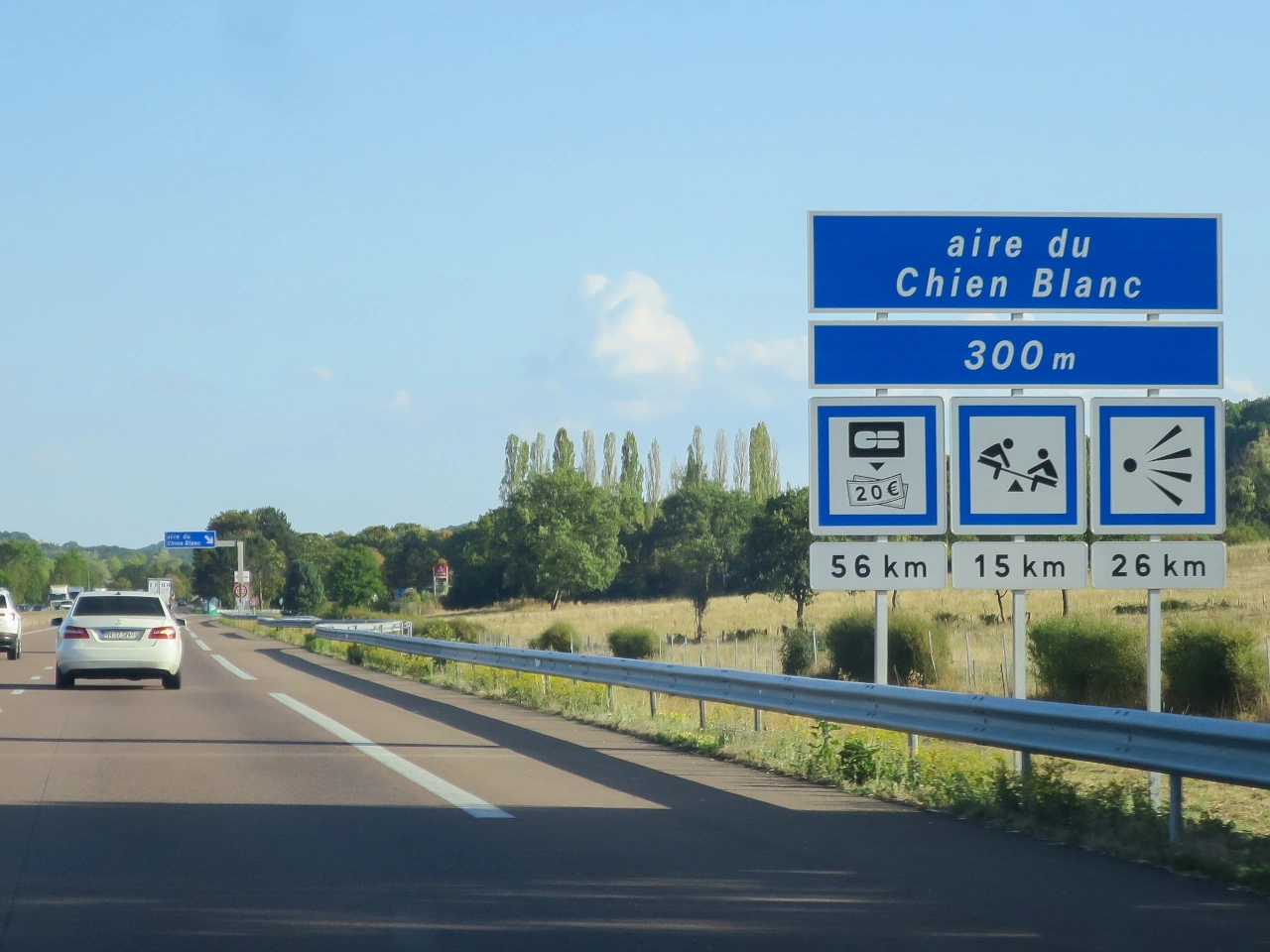
Wikimedia.org • Poudou99 • CC BY
120. Bed and breakfast
A bed and breakfast is a type of accommodation that provides guests with an overnight stay and breakfast, usually in a smaller establishment such as a private home, guesthouse or small lodging property. Facilities and services vary between establishments and countries.
Bed and breakfasts may be indicated on tourist or accommodation direction signs, particularly in areas where accommodation services are signposted for travellers. The symbols and terminology used vary between countries.

Wikimedia.org • Marc Mongenet • CC BY-SA
Can bed and breakfasts be indicated by road signs?
Yes. For example, Hampshire County Council includes bed and breakfasts among accommodation facilities that may qualify for tourist direction signs. Eligibility and the permitted sign design depend on the local road authority’s rules.
🔗 hants.gov.uk • Hampshire County Council, tourist accommodation signs
121. Dock
A dock or mooring is a designated waterside place where a boat or ship can stop and be secured. A dock may include a quay, pier, jetty or harbour structure, while a mooring may consist of a berth, buoy or other fixed point used to secure a vessel.
Road signs may direct travellers toward harbours, marinas, ferry terminals or other waterside facilities. The terminology and symbols used for docks and moorings vary between countries.

Wikimedia.org • Marc Mongenet • CC BY-SA
Can docks and moorings be indicated by road signs?
Yes. Direction or tourist signs may indicate harbours, marinas, ferry terminals and other waterside facilities, although the symbols used vary between countries.
122. Cable car
A cable car is a passenger transport system in which cabins or cars are moved by cables, often between locations with a significant difference in elevation. Cable cars are commonly used in mountainous areas, tourist destinations and some urban transport networks.
Road signs may direct travellers toward a cable car station or terminal as a transport or tourist facility. The symbols and terminology used to indicate cable cars vary between countries.

Wikimedia.org • Marc Mongenet • CC BY-SA
Can cable car stations be indicated by road signs?
Yes. Road or tourist direction signs may guide travellers toward cable car stations, although the symbols and sign designs used vary between countries.
123. Café
A café is an establishment where drinks and often light food or snacks are served to customers. Cafés may be located in towns, service areas, tourist destinations or other places where travellers can stop for refreshments.
Cafés and similar refreshment facilities may be indicated by service, tourist or direction signs. The symbols and terminology used vary between countries.

Wikimedia.org • Marc Mongenet • CC BY-SA
Is a café sign the same as a restaurant sign?
Not necessarily. Some road-sign systems distinguish between restaurants and establishments primarily offering drinks or refreshments.
 Café.
124. Motorhome wastewater disposal
Motorhome wastewater disposal is a designated facility where motorhomes, campervans or caravans can safely empty wastewater from their onboard tanks. Depending on the facility, separate disposal points may be provided for grey water from sinks and showers and for toilet waste from cassette or holding tanks.
Camper drainage facilities are commonly found at campsites, motorhome service areas and some rest or parking areas. Wastewater should be discharged only into the appropriate designated system and according to the instructions provided at the facility.

Wikimedia.org • Marc Mongenet • CC BY-SA
Where can camper drainage facilities be found?
Look for a designated motorhome service point, for example at a campsite or an equipped motorhome parking area. Some campsites allow non-residents to use their disposal facilities. Check access, charges and which types of waste the particular facility accepts.
🔗 argyll-bute.gov.uk • Argyll and Bute Council, motorhome service points
125. Ferry
A ferry is a vessel that transports passengers, vehicles or goods across a river, lake, sea channel or other body of water. Vehicle ferries form part of some road routes and allow drivers to continue their journey where no bridge, tunnel or continuous road connection is available.
Drivers approaching a ferry terminal should follow the direction signs, lane markings and instructions from ferry personnel. Boarding procedures, vehicle restrictions, schedules and payment requirements vary between ferry services.

Wikimedia.org • KiwiNeko14 • CC BY-SA
What should drivers do when approaching a ferry?
Follow the direction signs, designated lanes and instructions from ferry personnel, and wait or board only when instructed to do so.
🔗 dfds.com • DFDS, passenger-ferry check-in and boarding; operator example