Frontera internacionalAlemania

Aprende normas de tráfico con explicaciones claras y ejemplos visuales en nuestro libro ilustrado, diseñado para que estudiar sea sencillo y ameno.


65. Frontera internacional

Una frontera internacional es el límite legal entre dos países. Una señal fronteriza puede identificar el país al que se entra y recordar a los conductores que pueden aplicarse normas de tráfico, límites de velocidad, señales, requisitos del vehículo y normas documentales diferentes.

La propia señal de frontera normalmente no obliga a detenerse. Los controles de pasaporte, inmigración o aduanas pueden realizarse en un puesto fronterizo, pero algunas fronteras internacionales pueden cruzarse sin controles rutinarios en virtud de acuerdos regionales.
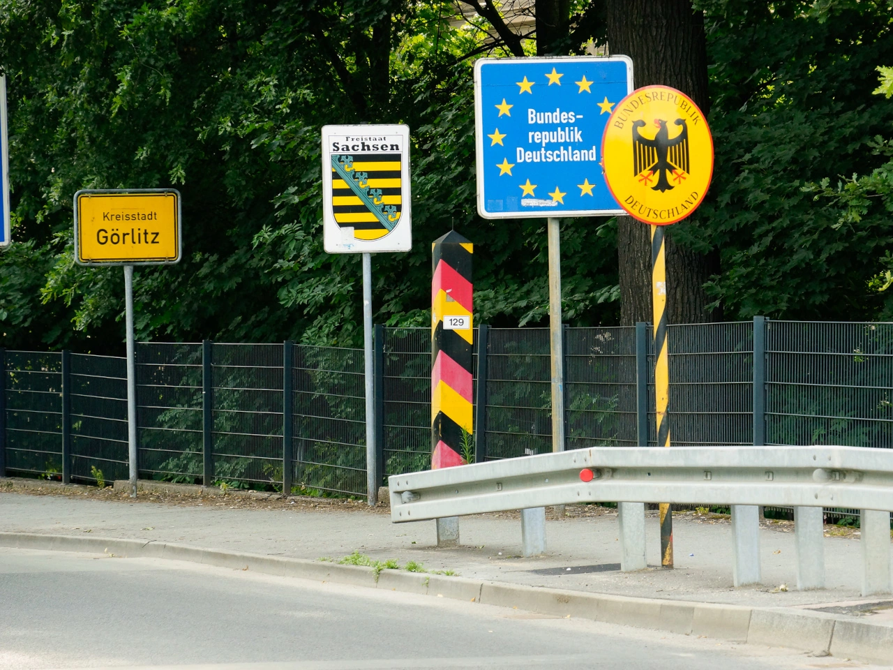
Frontera internacional
What is an international border?

An international border is the legal boundary between two countries.

How can you recognise an international border?

It may be identified by a country-name sign, national or regional symbols, flags, border posts, customs facilities or passport-control signs.

Does every international border have a road sign?

No. Borders may be marked differently, and some minor roads or open-border areas may have only a small identification sign or boundary marker.

Does a border sign require you to stop?

Not normally. Stop only when required by traffic lights, barriers, officers, customs signs, passport controls or another instruction.

When do the destination country’s traffic rules begin?

The new country’s traffic laws apply from the international boundary, not merely from the next town or major intersection.

Does the border sign itself impose the new rules?

No. The rules change because you have entered another country. The sign identifies that change of jurisdiction.

Can the driving side change at a border?

Yes. Where neighbouring countries use different driving sides, a specially designed road arrangement guides traffic safely from one side to the other.

Can speed limits change at the border?

Yes. The destination country may have different general limits for motorways, built-up areas, rural roads and particular vehicle categories.

Is the border sign a speed-limit sign?

No. Drivers must learn the destination country’s general limits and obey any regulatory signs displayed after crossing.

Can traffic-sign designs change?

Yes. Colours, symbols, shapes and road-marking conventions may differ, even when neighbouring countries follow similar international standards.

Can vehicle-equipment requirements change?

Yes. Requirements concerning safety vests, warning triangles, winter tyres, lights, toll equipment or environmental stickers may differ between countries.

Which documents may be required?

Depending on the journey, drivers may need a passport or identity card, driving licence, vehicle-registration document, insurance evidence, visa or customs documents.

Is a border check the same as customs control?

No. Border or immigration control concerns people and travel documents. Customs control principally concerns goods, cargo, money and applicable duties or restrictions.

Can immigration and customs controls occur together?

Yes. Both may operate at the same border facility even though they perform different legal functions.

Does every border have passport control?

No. Countries participating in an open-border area may normally cross internal borders without routine checks, although temporary controls may still be introduced.

Does every border have customs control?

No. Countries within a customs union may allow goods to move across their internal borders without ordinary customs duties or routine customs formalities.

Is an open border completely uncontrolled?

No. Police, customs and other authorities may still conduct lawful checks, enforce national rules and temporarily control the border where permitted.

May you cross the border anywhere?

Only where local law permits it. External or controlled borders may have to be crossed through an authorised border-crossing point during its operating hours.

Can a border crossing be temporarily closed?

Yes. Closures or restrictions may result from security measures, emergencies, severe weather, roadworks or administrative decisions.

Can certain vehicles be restricted?

Yes. A crossing may restrict heavy vehicles, dangerous goods, agricultural traffic, pedestrians or cyclists because of road design or border-control facilities.

May goods have to be declared?

Yes. Commercial goods, restricted products, goods exceeding personal allowances and certain amounts of cash may require declaration.

Do tolls or road charges change at the border?

They may. The destination country may use toll roads, vignettes, distance-based charges, low-emission zones or other payment systems.

Should you rely only on navigation software?

No. Navigation information may not include current border controls, vehicle restrictions or document requirements. Follow official signs and instructions.

What should you do before an international road journey?

Check the destination and transit countries’ traffic rules, required documents, insurance, vehicle equipment, tolls and border or customs requirements.

Do instructions from border officers override ordinary signs?

Yes. Follow lawful instructions from authorised border, police and customs officers, even when they temporarily differ from the normal traffic arrangement.

1 Alemania 2 Autopista 3 Vía rápida 4 Zona residencial 5 Zona 6 Límite de velocidad 7 Senda peatonal 8 Carril bici 9 Vía compartida 10 Advertencia de peatones 11 Túnel 12 Puente 13 Calle ciclista 14 Zona peatonal 15 Carretera de peaje 16 Aduana 17 Sentido único 18 Muelle 19 Pendiente 20 Carril bus 21 Parada de autobús 22 Calle sin salida 23 Señal de STOP 24 Ceda el paso 25 Glorieta 26 Vía con prioridad 27 Estrechamiento de calzada 28 Prioridad sobre el tráfico en sentido contrario 29 Ceda el paso al tráfico en sentido contrario 30 Paso de peatones 31 Paso a nivel 32 Dirección obligatoria 33 Zona escolar 34 Adelantamiento 35 Cruce de animales 36 Calzada deslizante 37 Desprendimiento de rocas 38 Aeronaves 39 Curva 40 Panel direccional 41 Circulación en sentido contrario 42 Obras 43 Viento lateral 44 Límite de altura 45 Límite de anchura 46 Límite de longitud 47 Límite de peso 48 Señal de control de velocidad 49 Barreras selectivas 50 Zona de bajas emisiones 51 Señal de dirección en intersección 52 Prioridad en la próxima intersección 53 Semáforos 54 Advertencia de semáforos 55 Semáforos peatonales 56 Marcas viales 57 Esquema de intersección 58 Zona avanzada para bicicletas 59 Indicador de velocidad 60 Permiso de conducir 61 Marcador de ubicación 62 Paneles de aproximación 63 Espejo de tráfico 64 Teléfono de emergencia 65 Frontera internacional 66 Paso inferior peatonal 67 Ruta ciclista 68 Fin de restricción 69 Estacionamiento 70 Prohibido estacionar 71 Prohibido parar 72 Estacionamiento en línea 73 Aparcamiento disuasorio 74 Kiss and Ride 75 Parquímetro 76 Disco de estacionamiento 77 Estacionamiento para personas con discapacidad 78 Gestión del tráfico 79 Marcha atrás 80 Atasco 81 Desvío 82 Intersección sin regulación 83 Estado de la calzada 84 Salida 85 Equitación 86 Permiso provisional 87 Mercancías peligrosas 88 Salida de emergencia 89 Rampa de frenado de emergencia 90 Carga sobredimensionada 91 Autopista ciclista 92 Carsharing 93 Límite de población 94 Pórtico 95 Panel de distancias 96 Apartadero de emergencia 97 Senderismo 98 Estacionamiento sobre la acera 99 Iglesia de carretera 100 Atracción turística ...